| « steephill.tv home • |
| « Stage 09 | Return to Tour de France 2011 Live Dashboard | Stage 11 » | ||||||||||||||||||||||||||||||||||||||||||||||||||
|
Categorized Climbs for Stage 10:
This stage preview is available in the following languages:
(We are looking for translations in ALL other languages. Please submit your translation with the stage no. and language in the subject title. If you don't see your preview posted within 12 hours then please resend your preview as an attachment if you didn't already do so because we've had problems with some inline character sets like German.) Stage 10 preview: Aurillac → Carmaux, 158 km (lumpy) |
|||||||||||||||||||||||||||||||||||||||||||||||||||
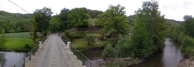 The peloton will cross this river literally known as Le Viaur to start the final of four modest climbs on stage 10, Cote de Mirandol Bourgounac |
Also follow steephill on Twitter for the latest race info and video updates. |
Más concretamente, la meta está al noreste de Toulouse. En el camino hacia Carmaux, una pueblo minero con explotaciones de carbón hasta hace poco, que alberga ahora por primera vez un final de etapa del Tour, hay cuatro pequeñas subidas de tercera y cuarta categoría, que van bordeando ríos por tranquilas carreteras secundarias, que como siempre, se pueden explorar arriba en google earth y streetview.
Hay varios cambios de dirección, incluyendo dos curvas muy cerradas, ya cerca de la meta en Carmaux, que se encuentra en una ligera bajada. HTC-Highroad buscará preparar el sprint mientras Europcar defienderá el jersey amarillo por primera vez en el Tour. -- Pablo González Poncela
 Streetview


