| « steephill.tv home • |
| « Stage 12 | Return to Giro d'Italia 2011 Live Dashboard | Stage 14 » | ||||||||||||||||||
|
profile | map | timetable | preview | results | photos | video Stage 13: Spilimbergo → Grossglockner This stage preview is available in the following languages:
(We are looking for translations in ALL other languages. Please submit your translation with the stage no. and language in the subject title. If you don't see your preview posted within 12 hours then please resend your preview as an attachment if you didn't already do so because we've had problems with some inline character sets like German.) Stage 13 preview: Spilimbergo → Grossglockner, 167 km (Mountain)
|
|||||||||||||||||||
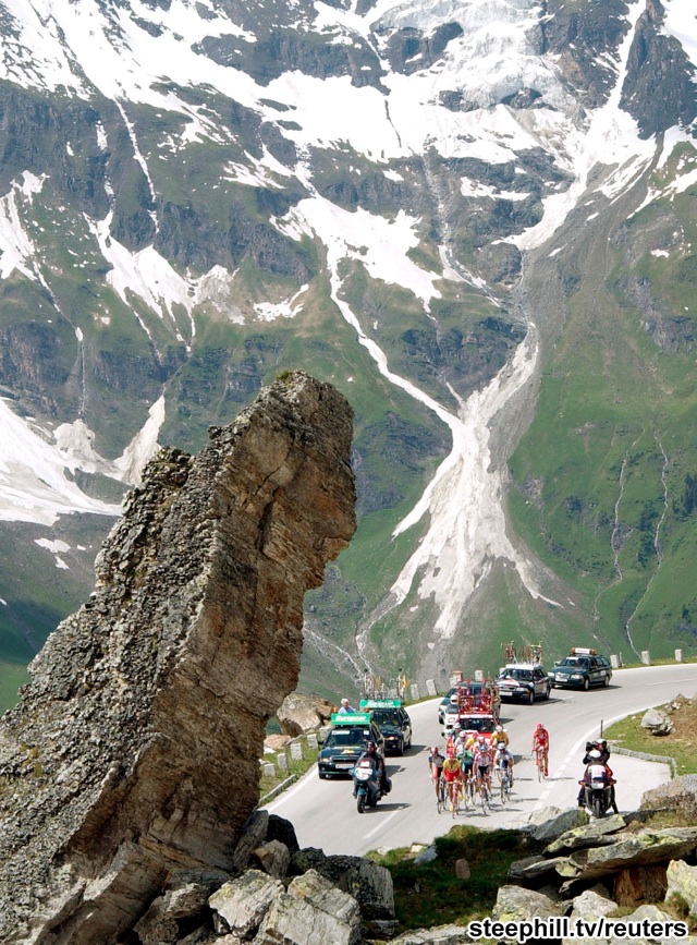 The Grossglockner is a famous climb used regularly in the Tour of Austria. This picture is from 2001. |
May 19 post: After the longest transfer between host towns without a rest day in this year's race, we are now in very Northern Italy. The fun (beaches) and games (sprint finishes) are now over as this year's Giro d'Italia gets down to serious business.
Stage 13 is the third of eight mountain stages and like most of the mountain stages this year it will have a "summit finish." From Spilimbergo, a small town located northeast of Venice we'll head due north into the Italian Eastern Alps, but only one of Friday's four categorized climbs is actually located in Italy. After cresting the day's first climb, the cat 2 Passo di Monte Croce Carnico, the riders will descend into Austria and continue north over two more climbs before finishing on the slopes of the highest mountain in Austria, The Grossglockner. However, the stage will stop short of the actual summit.
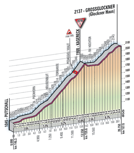
The Grossglockner is a famous climb used regularly in the Tour of Austria. At 3,798m above sea level, it's not only Austria's highest mountain, it's also the second most prominent mountain in the Alps after Mont Blanc. The road goes up to 2,504m elevation, but Stage 13 will stop at 2,137m. There are two tiers to the finishing climb (profile) with the first portion to Kasereck being given a category 1 rating for its 13.6 km length and average grade of 6.3%. Over the final 7.2 km there is a dip followed by a 6.2% climb for the remaining 4.5 km to the line.
It was about 40 years ago that the Grossglockner was last used in the Giro d'Italia. Apparently, there was a controversy at the end of the stage when the race leader was accused of hanging onto a team car after being dropped on a earlier climb. Things haven't changed much.
We've had few successful breaks at this year's Giro d'Italia which is rare, but we should see one on this stage because Alberto Contador seems eager to temporarily hand over the race leader's jersey. — Steve
 At 3,798m elevation, the Grossglockner is not only Austria's highest mountain, but it's also the second most prominent mountain in the Alps after Mont Blanc. Stage 13 will finish part way up the Grossglockner at 2137m elevation. photo w/permission: Michael Weger |
 The road up the Grossglockner like the other roads in Austria for Stage 13 are wide and well-paved. photo w/permission: teosaurio |
![]() Last (Ultimi) Km Profile
Last (Ultimi) Km Profile
Race Director Angelo Zomegnan Previews Stage 13 (1:00 Italian) — gazzetta


